
Other ITA web sites:

Kikai Caldera, Japan
Kikai island, seen from the air in the above photograph, taken in 2005, is one of two visible islands that are part of the mostly submerged Kikai caldera.
SOURCE: H. Seo, courtesy of the National Institute of Advanced Industrial Science and Technology (Japan), used with permission.
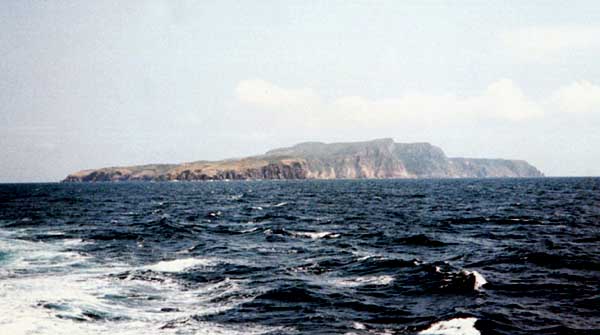
Kikai island, seen from the South.
SOURCE: S. Takeuchi, courtesy of Geological Survey of Japan, AIST, Tokyo, used with permission.
Kikai is a mostly submerged, 19-km-wide caldera south of Kyushu that was the source of one of the world's largest Holocene eruptions about 6300 years ago.
Pyroclastic flows traveled across the sea for a total distance of 100 km and devastated southern and central Kyushu, and ashfall reached the northernmost Japanese island of Hokkaido.
The eruption devastated southern and central Kyushu, which remained uninhabited for several centuries.
Post-caldera eruptions formed Iwo-dake lava dome and Inamura-dake scoria cone, as well as submarine lava domes.
Historical eruptions have occurred in the 20th century at or near Tokara-Iwo-Jima (also known as Satsuma-Iwo-jima), a small 3 x 6 km island forming part of the NW caldera rim.
Showa-Iwo-jima lava dome (also known as Iwo-jima-Shinto), a small island 2 km east of Tokara-Iwo-jima, was formed during submarine eruptions in 1934 and 1935.
Mild-to-moderate explosive eruptions have occurred during the past few decades from Iwo-dake, a rhyolitic lava dome at the eastern end of Tokara-Iwo-jima.
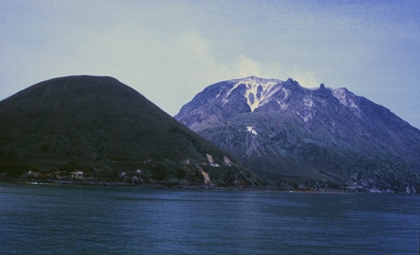
Satsuma-Iwo-jima, seen here from the SW, is a complex post-caldera island constructed on the NW margin of Kikai caldera.
Iwo-dake (Io-dake) on the right is a lava dome composed of thick rhyolitic lava flows.
Rounded Inamura-dake (left) is a scoria cone.
Shallow submarine eruptions have also occurred following the formation of the caldera about 6300 years ago.

A view from Hyakunodai, Kikai Island

This view from near the summit of the post-caldera cone Iwo-dake shows the western rim of Kikai caldera forming the peninsula (upper left) behind conical Inamura-dake scoria cone.
PHOTO SOURCES: Yasuo Miyabuchi, 1996 (Forestry and Forest Products Research Institute, Kyushu), courtesy of the Global Volcanism Program, Smithsonian National Museum of Natural History, used with permission, and Wikimedia Commons.
NOTE: The information regarding Volcano on this page is re-published from other sources. No claims are made regarding the accuracy of Volcano information contained here. All suggestions for corrections of any errors about Volcano photos should be addressed to the copyright owner noted below the photo.