
Other ITA web sites:
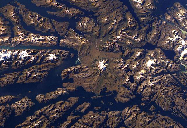
Mount Burney Volcano, Chile
Ice-covered Mount Burney occupies the NW part of the Munoz Gomera Peninsula in the spectacular glaciated Patagonian fjord region of southern Chile.
The volcano lies near the center of this NASA International Space Station image (with north to the left).
The rugged extensively glaciated topography surrounding the 1758-m-high Monte Burney is smoothed by volcaniclastic deposits from the volcano.
Monte Burney, a large volcano in the Patagonian region of Chile, is the southernmost of a chain of stratovolcanoes of the Australandean arc.
The 1758-m-high, ice-covered volcano lies about 200 km NW of the town of Punta Arenas.
Monte Burney was constructed on the western rim of a 6-km-wide caldera, which is partially filled with and surrounded by an unglaciated pyroclastic-flow deposit.
Flank vents produced andesitic-dacitic lava flows and pyroclastic material.
Collapse of the edifice produced a major debris avalanche that traveled to the SSW.
Two large plinian eruptions have been documented from Monte Burney during the Holocene.
The only known historical eruption of Monte Burney took place in 1910.
PHOTO SOURCE: NASA Space Station image ISS006-E-41451, 2003 , courtesy of the Global Volcanism Program, Smithsonian National Museum of Natural History, used with permission.
NOTE: The information regarding Volcano on this page is re-published from other sources. No claims are made regarding the accuracy of Volcano information contained here. All suggestions for corrections of any errors about Volcano photos should be addressed to the copyright owner noted below the photo.