|
|
DEFINITIONS
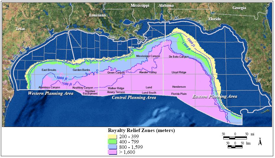
The GOM Outer Continental Shelf (OCS) is divided into the Western, Central, and Eastern Planning
Areas (figure 1). Many of the data presented in this report are subdivided according to water depth.
These divisions (1,000, 1,500, 5,000, and 7,500 ft) are illustrated in figure 1, along with Deep Water
Royalty Relief (DWRR) zones (200, 400, 800, and 1,600 m) for reference.

Figure 1. The Gulf of Mexico OCS is divided into Western, Central, and Eastern Planning Areas. Water-depth categories used in this
report are shown in addition to shaded Deep Water Royalty Relief Act zones. (Click to enlarge)
There are a variety of criteria that can be used to define deepwater. The threshold separating shallow- and
deepwater can range from 656-ft (200-m) to 1,500-ft (457-m) water depth. For purposes of this report,
deepwater is defined as water depths greater than or equal to 1,000 ft (305 m). Similarly, ultra-deepwater
is difficult to define precisely. For purposes of this report, ultra-deepwater is defined as water depths
greater than or equal to 5,000 ft (1,524 m).
A few other definitions are useful at this point:
- Proved Reserves are those quantities of hydrocarbons that can be estimated with
reasonable certainty to be commercially recoverable from known reservoirs. These
reserves have been drilled and evaluated and are generally in a producing or soon-to-be
producing field.
- Unproved Reserves can be estimated with some certainty (drilled and evaluated) to be
potentially recoverable, but there is as yet no commitment to develop the field.
- Known Resources in this report refer to discovered resources (hydrocarbons whose
location and quantity are known or estimated from specific geologic evidence) that have
less geologic certainty and a lower probability of production than the Unproved Reserves
category.
- Industry-Announced Discoveries refer to oil and gas accumulations that were announced
by a company or otherwise listed in industry publications. These discoveries have not
been evaluated by MMS and the reliability of estimates can vary widely.
- Field is defined as an area consisting of a single reservoir or multiple reservoirs all
grouped on, or related to, the same general geologic structural feature and/or stratigraphic
trapping condition. There may be two or more reservoirs in a field that are separated
vertically by intervening impervious strata or laterally by local geologic barriers, or by
both.
More detailed definitions may be found in the annual Estimated Oil and Gas Reserves, Gulf of Mexico
Outer Continental Shelf, December 31, 2000 report (Crawford et al., 2003).
This report refers to deepwater developments as both fields (as defined above) and by operator-designated
project names. A field name is assigned to a lease or a group of leases so that natural gas and oil
resources, reserves, and production can be allocated on the basis of the unique geologic feature that
contains the hydrocarbon accumulation. Appendices A and B provide locations, operators, and additional
information regarding these fields and projects. The field�s identifying block number corresponds to the
first lease qualified by MMS as capable of production or the block where the primary structure is located.
Note that the term �oil� refers to both oil and condensate throughout this report and �gas� includes both
associated and nonassociated gas. All production volumes and rates reflect data through December 2002
(the most recent, complete data available at the time of this publication).
 - Please bookmark this page (add it to your favorites).
Copyright © 1995-2010 ITA all rights reserved.
|
|
Cover and Title Page
PREFACE
INTRODUCTION
BACKGROUND
LEASING
DRILLING AND DEVELOPMENT
RESERVES AND PRODUCTION
SUMMARY AND CONCLUSIONS
. . . Feedback

| |